
View also subpage CB Observations Gov. Bk/Colpitt Lake (Citizen Science Project).
Introduction
Salt contamination of surface and ground waters is increasingly recognized as a major threat to aquatic life. It is most problematical in areas where there is heavy use of road salt to reduce ice hazards in the cold months. Road salts wash into storm sewers etc most of which empty into lakes or in the Halifax area, directly into the ocean. Fertilizers can also contribute to salt content.
There are two major actual or potential ill-effects of elevated salt input to surface and ground waters:(i) direct toxic effects on aquatic organisms; (ii) disruption of normal seasonal turnover in deepwater lakes such as Williams and Colpitt Lakes; this can result in loss of habitat and accelerated eutrophication. As well, increasing salt loading is typically accompanied by increased loading of other contaminants.
On measurement of salt content

Electrical Conductivity and Temperature on upper Governors Brook, Nov 30, 2022 Details
Click on image for larger version
Electrical Conductivity (EC) is a readily obtained measure of the salt content of water. The values vary slightly with temperature, and so temperature of the water should be measured at the same time; most instruments measure both EC and temperature. There are a variety of instruments available for such measurements of varying cost and reliability; I have had consistently satisfactory operation, minimal need for calibration etc with one particular instrument costing less than $50; there are undoubtedly others, but it’s important to confirm accuracy with use of a standard. More info on EC measurements is available here. Measurements of temperature and EC using such instrumentation lend themselves to Citizen Science observations such as those conducted by C.B. on Governors Brook/Colpitt Lake – dp
Reports related directly to Watersheds associated with the Backlands
– Existing Water Quality and Characteristics of Spryfield Area Lakes and McIntosh Run
Draft report by J.G. Ogden, March, 1973. From files of Williams Lake Conservation Company. 42 pages. Sampled were Chocolate Lake,
Catamaran Pond, Colpitt (Colbart) Lake, Frog Pond, Whimsical (Tiger) Lake, Williams Lake Maclntosh Run. Wide range of measurements and related observations.
– Water quality measurements on Williams Lake and Colpitt Lake (Halifax, N.S.) Dec 7-13, 2015 with reference to possible impacts of road salt
Report to Williams Lake Conservation Company (WLCC) by David Patriquin, Jan 6, 2016. There is evidence for delayed (or possibly absence) of the fall turnover of the water column in Williams lake which may be related to salt induced stratification. Conditions have clearly deteriorated since 1990/1991. Even though three-quarters of the watershed is undeveloped, salt inputs from the other 1/4 are having significant impacts on the health of both Colpitt Lake and Williams Lake.
– Williams Lake, Halifax. Nova Scotia: An Investigation of the Aquatic Ecosystem of an Urbanizing Watershed [1991/1992].
Report by R. Scott to Nova Scotia Department of the Environment, 1992. 39 pp. The document includes detailed bathymetry; vertical profiles of temperature, electrical conductivity (salinity) and pH observed in 1990/91; nitrogen, phosphorous and chlorophyll; and contrasts these observations with those of earlier studies during a period of higher salt and nutrient loading.
– Long-term evaluation of the impact of urbanization on chloride levels in lakes in a temperate region
R.Scott et al., 2019. Journal of Environmental Management Volume 244, 15 August 2019, Pages 285-293

Graph adapted from Fig 6 in Scott et al., 2019. Regression line relates chloride concentrations in the spring of 2013-2017 to the percent of a watershed that is developed for 9 Halifax lakes. EC values on the right correspond to the chloride values, based on the relationship given in AECOM (2020). The CCME Guideline for long term exposure to chloride is 120 mg/L (the dashed red line). Click on image for larger version.
Paper by researchers at Centre for Water Resources Studies, Dalhousie University Halifax. Observations were made on 9 lakes in Chocolate Lake Run Drainage Basin (Bayers, Second Chain, Lily Pond, First Chain, Chocolate. Lakes) and McIntosh Run Drainage Basin ( Bayers, Cranberry, Hail, Witherod, Long Lakes) on Halifax south mainland. “In this paper, nine lakes in the Halifax region of Nova Scotia, Canada, were monitored over 35 years to observe Cl concentrations prior to, during, and after urbanizing development. Cl concentrations were observed to increase in most study lakes over the monitoring period and all nine exhibited seasonal trending in response to winter de-icing activities. Six of the lakes achieved a steady-state Cl level after an initial increase in response to development activities, two are potentially still in transition, and one was unaffected by development activities. Watershed land use was found to be a good predictor of the springtime concentration of Cl and can help to inform decision making surrounding development activities.When the percent of developed land was 25% or more, the Cl concentrations tended to exceed Canadian freshwater quality guidelines for the protection of aquatic life.”
– Synoptic Water Quality Study of Selected Halifax-Area Lakes: 2011 Results and Comparison with Previous Surveys
Pierre M. Clement and Donald C. Gordon, 2019.Canadian Manuscript Report of Fisheries and Aquatic Sciences 3170
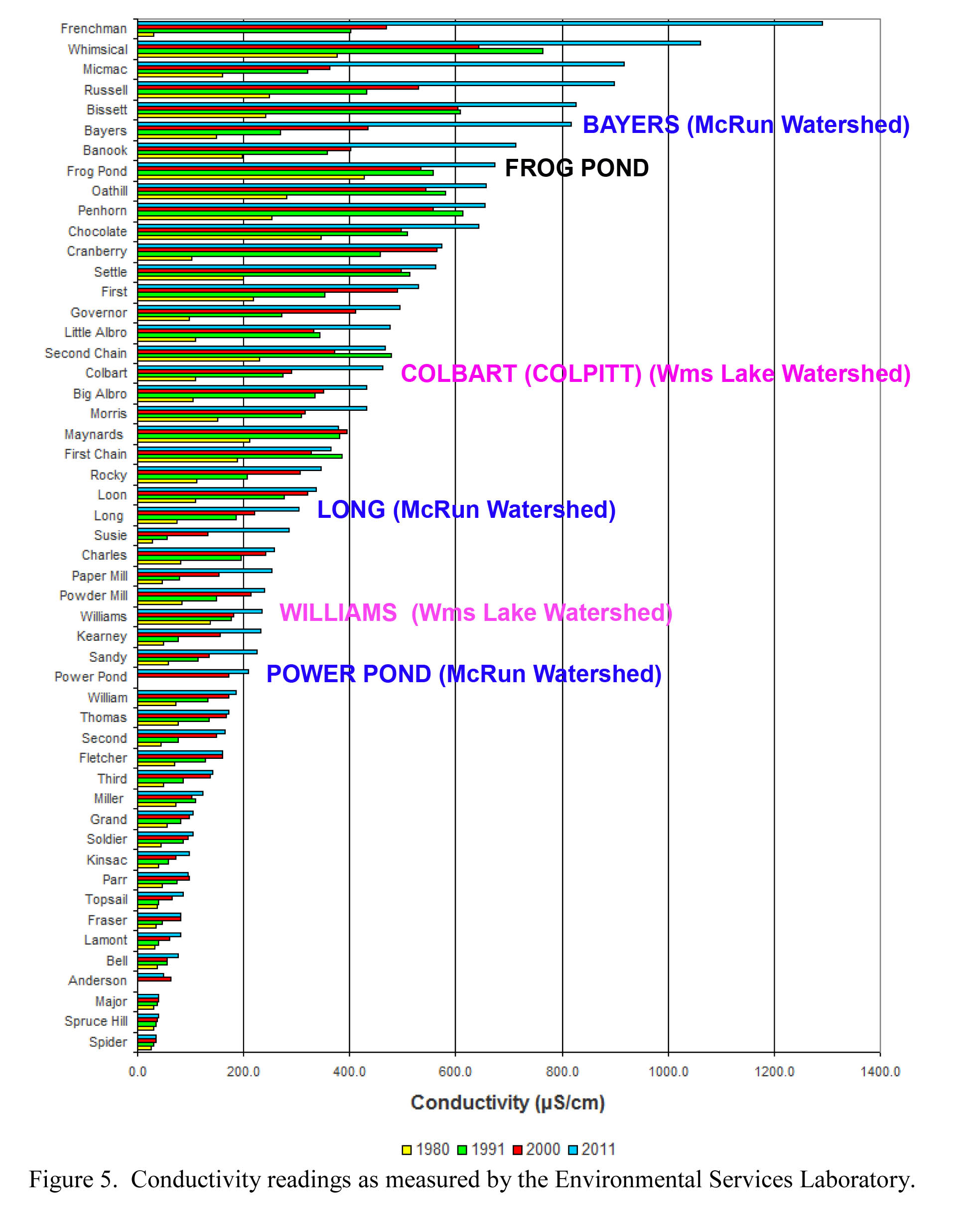
Fig 5 from 2011 Synoptic Study show Electrical Conductivity values for 51 lakes. Lakes in McIntosh Run and Williams Lake Watersheds are highlighted, plus Frog Pond
“The fourth synoptic survey of water quality in 51 Halifax-area lakes was conducted on 7 April 2011….The results are compared to those of similar surveys previously conducted in 1980, 1991 and 2000. [Another set of observations was obtained in 2021, results are not yet available]In 1980, the Department of Fisheries and Oceans (DFO) at the Bedford Institute of Oceanography undertook a project to measure the water quality of selected Halifax-area lakes. In partnership with Dalhousie University, the Nova Scotia Department of Environment and the federal Department of Environment (now Environment and Climate Change Canada), surface water samples were collected on a single day from 50 lakes in April 1980 using a helicopter and small boats (Gordon et al. 1981). These lakes were subjectively selected by the project leaders to cover a wide range of characteristics (e.g. location, size, watershed, degree of watershed development) and uses (e.g. water supply, recreation, wildlife habitat). These temperate lakes undergo a pronounced seasonal cycle. They are subject to potential stratification during the winter, when covered with ice, and in the summer when thermoclines can develop. However, in the early spring, immediately after the ice departs, lake water is generally well mixed from surface to bottom so that the properties measured in surface samples are representative of the entire lake volume. Standard water quality variables (e.g. pH, major ions, nutrients and organic matter) were measured and the resultant data were used to rank the lakes with regard to water quality (Gordon et al. 1981).
Related Local Studies, Info. (Sandy Lake, Bedford)
- EC (salt): Definition and Measurement
- EC & Lake Stratification
- A DRAFT Report On the State of Sandy Lake, the Historical Trends and its Future Trajectory
Some Recent Scientific Literature
- A review of the species, community, and ecosystem impacts of road salt salinisation in fresh waters
William D. Hintz, Rick A. Relyea 2019 in Freshwater Biology “We found that road salts negatively affect species at all trophic levels, from biofilms to fish. The concentration at which road salt triggered an effect varied considerably. Species-level impacts were generally sub-lethal, leading to reductions in growth and reproduction, which can be magnified by natural stressors such as predation. Community-level impacts including reductions of biodiversity were common, leading to communities of salt-tolerant species, which may have implications for disease transmission from enhanced recruitment of salt-tolerant host species such as mosquitoes. At the ecosystem level, road salts alter nutrient and energy flow. Contaminated wetlands could see greater export of greenhouse gases, streams will probably export more nitrogen and carbon, and lakes will encounter altered hydrology and oxygen dynamics, leading to greater phosphorus release from sediments…While it is necessary to keep roads safe for humans, the costs to freshwater ecosystems may be severe if actions are not taken to mitigate road salt salinisation. Cooperation among policy makers, environmental managers, transportation professionals, scientists, and the public will be crucial to prevent a loss of ecosystem services including water clarity, drinkable water, recreation venues, and fisheries.” - The effects of road salt on freshwater ecosystems and solutions for mitigating chloride pollution – A review
Sebastian Szklarek et al., 2022 in Science of the Total Environment Highlights
• NaCl application causes short- and long-term negative impacts on water and soil.
• NaCl releases pollutants from soil and sediments.
• Increasing Cl concentration decreases the self-purification processes of water.
• Alternative de-icing agents had similar effects to NaCl, or more negative ones.
• System solutions preventing water pollution by road salt are necessary. - Novel ‘chemical cocktails’ in inland waters are a consequence of the freshwater salinizationsyndrome.
Kaushal, S.S.et al., 2019. Philos. Trans. R. Soc. B Biol. Sci. 374 . - Can salinity trigger cascade effects on streams? A mesocosm approach.
Canedo-Argüelles et al., 2016 Sci. Total Environ. 540, 3–10.
Page posted Jan 2, 2023 – dp