
Drafting
ECOLOGY WORKSHOP PAGES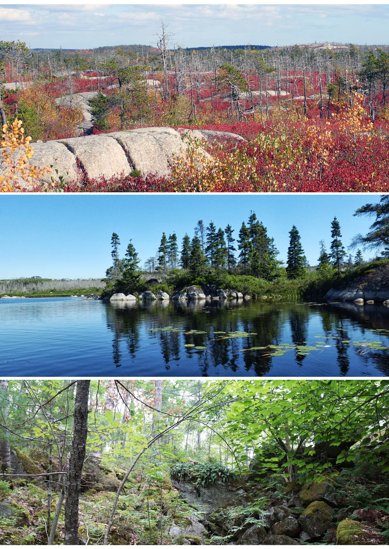 1. Introduction (DP) 1. Introduction (DP)Whats there? – 2. Homework (DP) – 3. Overview of Environmental Factors (DP) – 4. JP-Crowberry Barrens & Fire Mgmt (DP) – 5. Forest Birds (JBD) – 6. Specialist Birds (FL) – 7. Some Conservation Perspectives (KM) —-> 8.Discussion (This Page) Synthesis – 9. Highlights – 10. Threats & Challenges |

Yellow Birch-lined Lawton’s Brook, Oct 21 2022
DP: I was very superficial in the treatment of the plant communities there’s certainly a lot more besides the Jack Pine-Broom Crowberry communities, very interesting very beautiful out there like the corridors of the Yellow Birch down the Lawton’s Brook and between the Colpitt Lake and Williams Lake’ & there’s lots of other features that are really important; the wetlands we really need to look at – there’s quite a diversity of Wetlands.
RC: …in your list of of threats to the Backlands, there are about seven or so, you didn’t list that if there’s development, there will be loss of carbon sequestration; now you are mainly concentrating on things that are unique about the Backlands…perhaps it could be argued that there’s a lot of rock barrens and so maybe the the ability to sequester carbon is much less than you expect & so developers might use that argument; but there are also the wetland… is there a way to do the carbon accounting? Is it relevant? I just wonder if if you were someone else could comment.
DP: Carbon accounting could certainly be done; we should always think about the combined climate and biodiversity crisis… there is often a bit of a tradeoff, more carbon storage and less biodiversity and vice versa, it’s often the naturally stressed ecosystems that host some of the rarest, most threatened species, we see some of that in the Backlands.
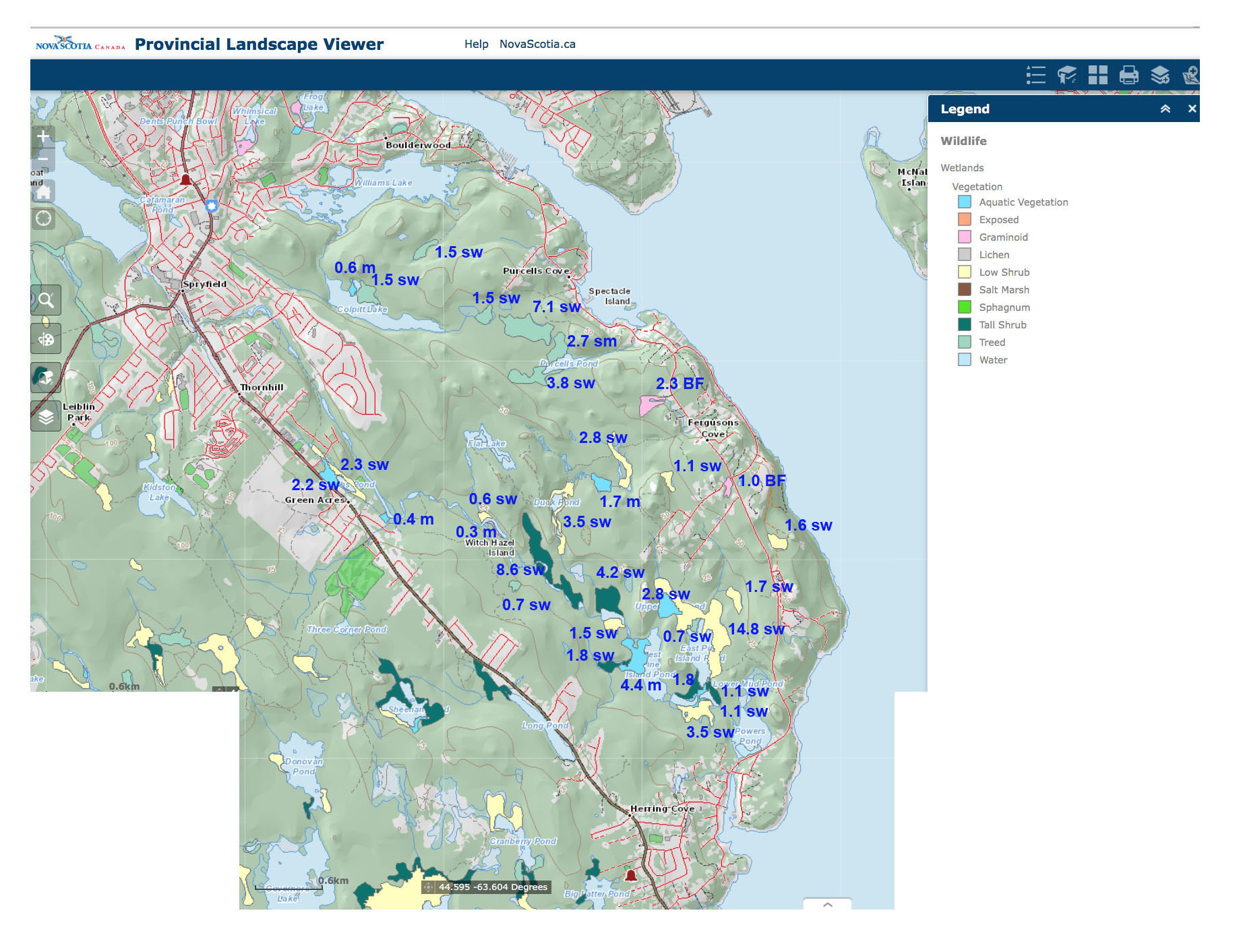
Wetland Vegetation. Area in hectares and wetland type inserted.
sw=swamp, m=marsh, BF=bog or fen
Click on image for larger version
SS: …The map of wetlands you showed us should be very helpful.
DP Thx. One reason I have put those maps together is that I am starting to get requests about things like wetlands.
Another comment I have heard from several people is ” there must be lots of Old Growth forest back there.” In fact there is not much Old Growth but there are components of Old Forests. So in the Williams Lake Backlands there’s some big old pine trees that survived the fires and those create elements of Old Forest or Old Growth in the same area where there is earlier successional stuff’. That’s why I suggested to Joshua that he have a look look at the 2021 Betts paper and see how many Old Forest bird species he cites are present in the Backlands… because that’s the reality as the birds are a really super indicator.
As it turns out, as documented by Joshua, we’re getting a lot of Old Forest bird species in the Backlands, so there’s enough old forest habitat to support those birds.
Today there’s very little old growth in Nova Scotia, so we want to keep what we have, but we should be talking about Old Forest because that’s what we need to work on and and there’s there’s old forests components in the Backlands.
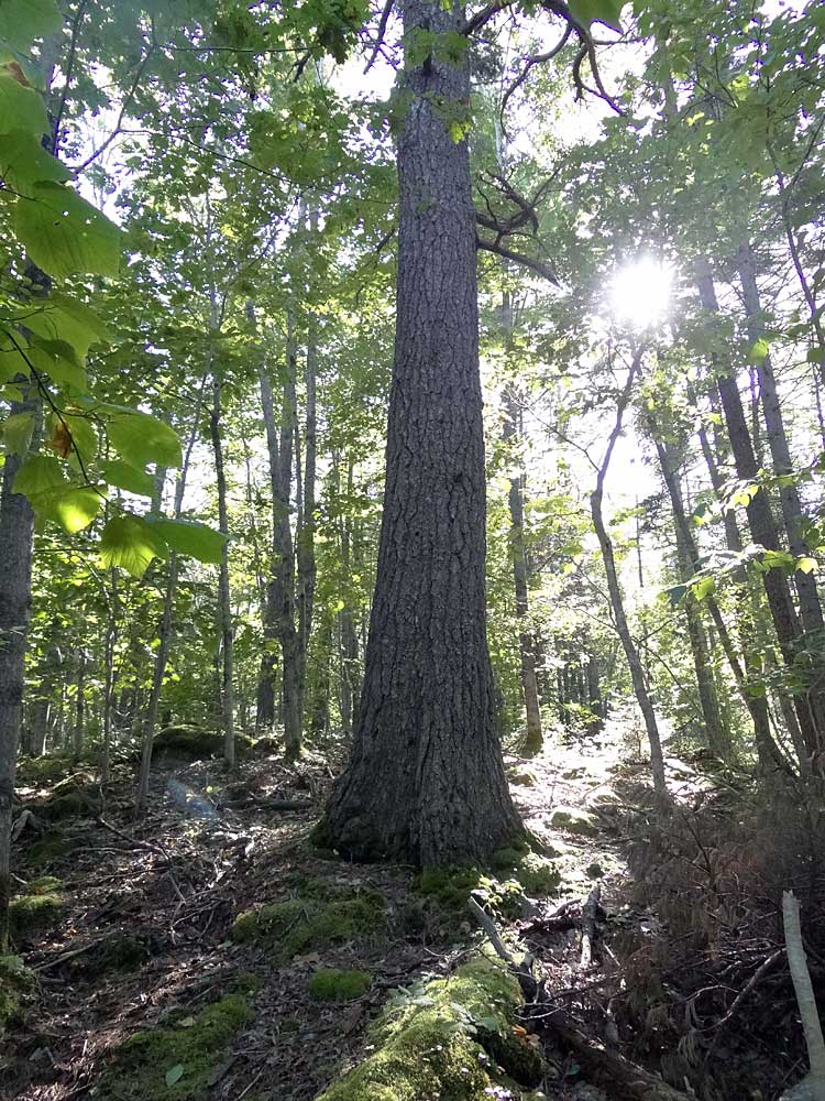
Big White Pine in Williams Lake Backlands
One thing I ask people to keep an eye are Big Trees. I started this at Sandy Lake (Bedford); every time I see a big tree, I measure it and record its location. I call a big tree anything that’s close to 20 inches (50 cm) diameter and larger. It turns out if you do that, it can be useful for mapping Old Forest, so I’ve started to do that in the Backlands.
Then you see situations where you have a generally young Forest but with some old trees, I was looking in the lower McIntosh Run area, and again it’s similar, a lot of younger forest there but there’s some really old Oaks and Pines down there. So these are things we need to kind of flush out for the Backlands.
P.M. I just wanted to kind of respond to that comment on the wetlands because over the past number of years we’ve been mapping the wetlands in the Williams Lake Watershed section of the Backlands; we haven’t ventured down to the lower end of the Backlands
Te wetlands are really really interesting. There’s a lot of diversity in the wetlands but. generally they tend to be quite small; there are some larger ones back there though. Because they’re small that doesn’t mean they’re not important. I think that’s the danger that we have to be really looking out for because those are the ones that are very vulnerable to be lost through development; they’re not necessarily covered under the Wetland Policy so they’re not subject to regulation and so they get missed and there’s nothing there to really protect them. Developers might not even be aware of them so we’re trying to get a handle on the type of wetlands we have in the area & how they are connected to one another.
This idea of underground drainage is so interesting for this place and often underground drainage sort of emerges at the surface then it disappears again and you don’t even really realize what’s going on beneath your feet, but you will see these little Wetlands scattered around at the surface so we’re trying to get that sorted out for the upper part of the Backlands.
We haven’t moved it into a the lower part of the Backlands which is where you do see the larger wetlands generally.
People have started to quantify carbon sequestration but when you look at that area coverage of wetlands, it is a relatively small component overall although they are I think they are very important aspect of the Backlands landscape.
So I think it would be worthwhile trying to figure that (carbon sequestration) out especially for the larger ones and peat bogs; people aren’t paying attention to it …we really have to try and continue to take that bigger picture approach that David was talking about, combining Wetlands, biodiversity, forest cover; all those elements of the landscape are are important for carbon sequestration.
We got started with the Shaw Wilderness Park. So that’s very very helpful, that’s a northern anchor in the Backlands; go to that southern anchor and then the piece in between. So those lands in between I think right now the largest wetlands in the area are probably sitting in some of the privately held parts of the Backlands… they’re large enough that they might be protected through the Wetland policy for the province at least protected to the extent that it would require a development permit for development to occur and then you can you know kind of get an anchor on what to do about controlling or redirecting development around them. I just want to contribute that because the question came up.
NB: I think you’re right that some of the most important features exist because the area burns over and that does probably present a problem… there are going to be a lot of people perhaps who are not going to want fires in their midst or as close as the Backlands are.
So I just sort of flagged that; it’s something we we should mull over at one of our meetings and try try to figure out how to present it. It is also one of the reasons why you can’t make it in terms of sequestration at least the Forest Part because the the carbon is periodically reduced although the period may be long enough that it gives us some some hope um because the next burning would be probably 60 years or so and it’s within that time frame we need to get climate change under control.
I have another specific question for Fulton and that was whether or not the Whip-Poor-Wills that he mentioned had been heard or recorded at all recently?
FL: The last record in that area was 2009. There had the other records of Whip-Poor-Wills in other area sof NS, but not in the Backlands since 2009. oh sorry there was one record by the nine-hole golf course which is between long ponds and Spryfield, I forget the name of it…that would have been both about five four five years ago, a singing bird just passing through; that’s the last time Whip Poor Will has been recorded here on a house they they can still show up. I’m still listening, as long as the food source is there and the habitat is there there are enough in Eastern North America, even in the eastern United States in particular particularly Maine and a Vermont, New Hampshire, Massachusetts so we could get we could get a pair that could nest and if we could, we have to be prepared. You have to keep the habitat.
ML: Regarding the wetlands, we have some reports on wetlands in the backlands; they’re on the Google Drive and then there’s wetland reports done by Ducks Unlimited in the last within the last two years.
A question for Patricia because Patricia you said that your student is doing mapping of the wetlands in BBB lands and those lands are of great interest to to us. Fulton and myself and a couple of other people Kathleen went out one time in 2020. I think we were waiting waiting for the birds to wake up in the morning and we h we’ve done a report x on that if that’s of any use. I was wondering if you could speak to at all speak to what your student is doing or if it’s too early to talk about it.
PM: a number of years ago David is familiar with the work we had a student who used different types of arial imagery to identify potential vernal pools and full wetlands throughout the Williams Lake Watershed. This is visual mapping and then we we started a process of going into the field to try and identify which ones were actually wetlands because it’s really hard to in an area with so many with some really small wetlands and it’s hard to see them all so we were hoping we could use satellite imagery & aerial photos to help us out. I’m not sure if that report I’ve ever made it onto your website but then a couple years later another student did more mapping and examined the wetlands and micro-hydrology of the Watershed; that was Tessa Williams and I think that study is on the Williams Lake website and Isabel S is looking very specifically at the BBB lands project.
IS: I’m working on this as a part of the Master’s in planning program, our independent project, so basically I’m looking at it through the site visit. So ground truthing a lot of the micro-hydrology that has been mapped through the aerial imagery; and we’ve gone out and done a couple site visits now and are looking at doing another one. So once I have those kinds of results, I’d be happy to share them; there’s also a GIS desktop analysis component so looking at that the hydro analysis that will be something that I’m doing this month and then looking at some other criteria as well. So basically just there’s the opportunity to make a case for protecting this area with the plan pending and so that’s what I’m focusing on now.
PM: One thing that I’ll never forget, Dave I went on that walk with you and Nick a number of years ago and we’re walking through the area, it was so dry I remember it was a hot hot day right and we came to these wonderful these Boulder swales; they are as dry as bones but they are actually a wetland in their own right and they’re very special to that area.
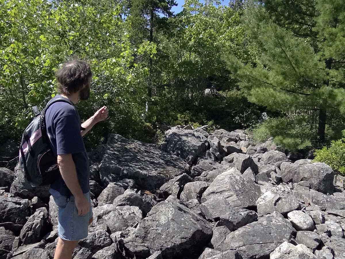
Boulder Field in the geological contact zone between Williams Lake and Colpitt Lake. View more pics
DP: Nick really did a wonderful job looking at them and documenting that sort of thing; he made the point that they are wetlands but are never recognized as such, and there are lots of those. a there’s lots of Boulder Fields around Halifax, I see more and more all of the time…
KH: I was wondering about those Bolder Fields because I sort of forgotten about them do you have some good pictures?…
DP: yes. there’s a lot of them in the the contact zone between Williams Lake and Colpitt Lake; that’s very special Zone to me, that whole area between Williams and Colpitts, the contact Zone between the granitic rocks and the Meguma rocks; it’s actually some distance below the ground and it’s filled in with all these wetlands and boulders and everything else and there’s a lot of Boulder fields at the bottom of some of those slopes…. very interesting. There is literature on them in the US and so they are known but not sort of widely acknowledged and recognized.
There is one at the Southdale wetland in Dartmouth and they’re gonna make a parking lot there!
PM: You can see one very clearly when you’re standing on the Ridge at Colpitt Lake and looking across at the other side, it’s right there in front of you it’s just above the little Marsh; it’s really obvious.
DP: some of them are very big. I remember the first time I saw one, a really big boulder field out I thought it must have been some horrendous Quarry at one time until I talked to geologist Marcos Zentilli who told me what what they actually are.
A question on the chat from Jennifer: How can we make the Backlands a larger conservation priority especially to government?
KM: Excellent question… it is already on the radar of several organizations to a degree and a group of us meet regularly to hone in on how to elevate the conservation priority, especially with the province.
One thing that we can position ourselves for is, if you know some of the government’s conservation priorities...e.g., the provincial and federal SAR lists; there is science behind tham and they’re very comfortable with prioritizing places that have species on the list.
One thing that could be challenging for the Backlands is that there’s entire ecosystems that would be great to preserve like the Jack Pine-Broom Crowberry ecosystem but there isn’t an endangered ecosystem list for Nova Scotia. But we are perhaps just a couple steps away from that… they are developing classification systems for different types of ecosystems, for example, the Forest Ecosystem Classification system, so they have a way of categorizing their forests and could in theory do mapping and other planning to say what are the rarest Forest types of Nova Scotia and make those conservation priorities.
Of course that’s not going to work for the Jack Pine-Broom Crowberry barrens, however they’re just about to come out with a classification system for “everything else”. So everything that doesn’t fit into the Forest Category or the Wetlands category, there is someone working on a classification system for that. So once that comes out, we could try to work with the province and then perhaps Jack Pine-Broom Crowberry barrens could emerge as rare and a conservation priority for the province.
There’s also other land holders in the Backlands that could do more work in the area like the Nature Conservancy and the Nature Trust so we can continue to meet with them and try to keep getting on their top priority list. So those should be some ways Jennifer.
SS: I’m thinking about the indigenous relationship to the area and the fact that we don’t know a whole lot about that. I guess I’m wondering who, whether anybody’s actually been pursuing that, what we know about about any efforts that have been made?
…We agreed we need to understand better the indigenous relationship to the area.
END