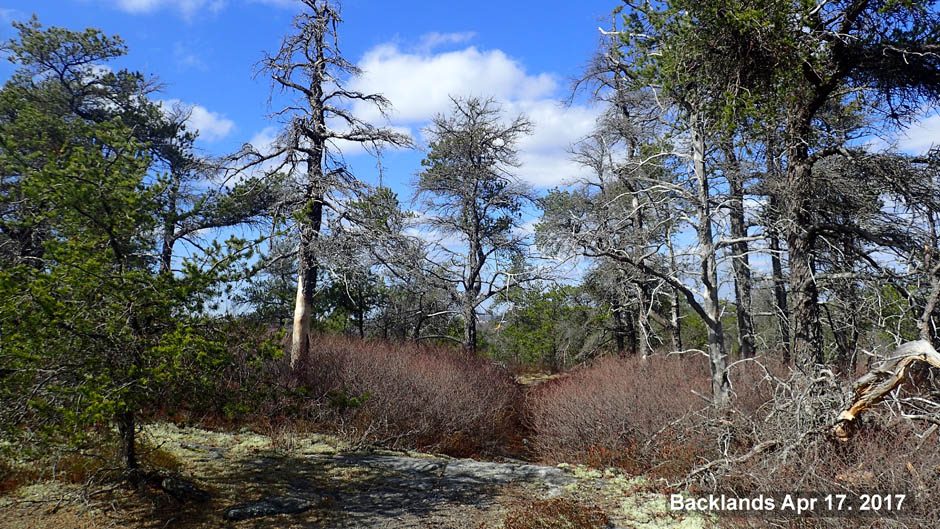
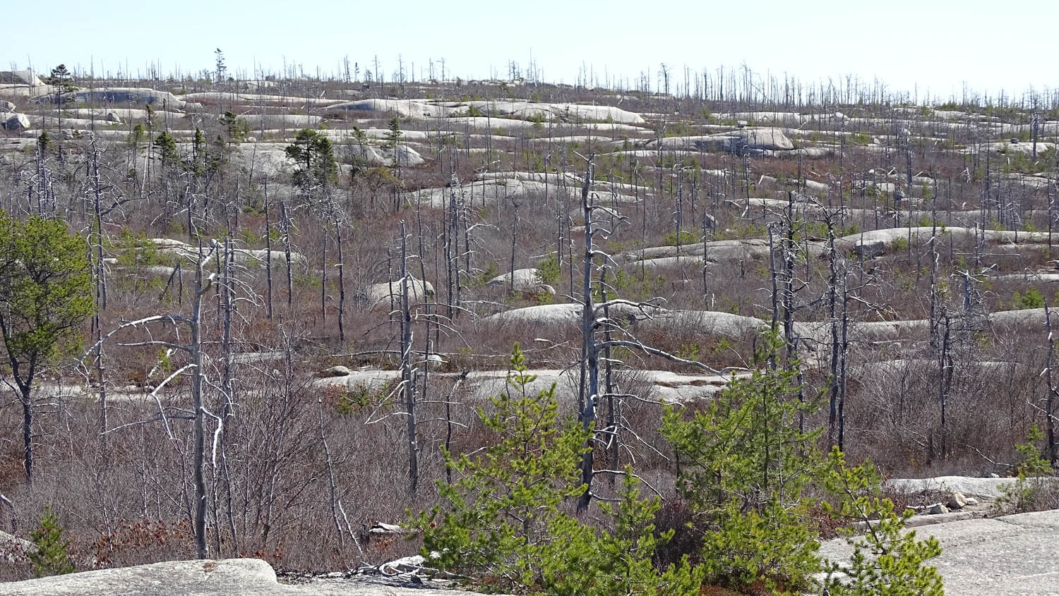
Field of whalebacks in the Backlands on Apr 11, 2021 (David P photo). The dead trees are Jack Pines that burned in the Spryfield Fire of 2009
The Backlands have one of the best and most accessible fields of whalebacks or roches moutonnées in Nova Scotia, otherwise common in glaciated areas of the Canadian Shield and Greenland.
During the Last Glacial Period of the Quaternary, 115,000 to circa 11,700 years ago, the area of the backlands (as well as Atlantic Canada) was covered by a thick ice sheet 1 to 3 kilometres thick, very much like Greenland and Antarctica are today.
With so much earth’s water trapped in ice, 18,000 years ago sea level was 120 m below present, hence ice was not floating, but lying directly on land. But solid ice is not static, it moves; formed by accumulating snowfall in the highlands, it flows downhill, centimetres to metres a day, as can be measured in alpine glaciers, which are essentially “rivers of ice”.
Where the ice is in contact with the earth’s surface, the pressure by ice is enormous, only slightly less than 1 to 3 km under the ocean (remember what happened to the pressure that crushed Titan submersible near the Titanic).
When pressure is applied to ice, its melting point is reduced so it turns to water. When the pressure is removed, however, it turns back into ice; this process is called ‘regelation.’ Solid ice is an exception in nature, because it occupies more volume (9%) that the water that forms it, which is lucky, because that way it is less dense, lighter than water, and therefore floats on it, otherwise life would not survive in our lakes.
As the ice sheet moves, any irregularity will create areas of high pressure where the ice will melt. This water will penetrate on any preexisting cracks and when it refreezes by regelation, it expands and is able to break the rock apart.
In other areas, such as a depression, the ice will refreeze and thus carry (entrain) downhill loose blocks of rock or soil. These rock fragments rub on the underlying rock and acts as sandpaper, or more like a carpenter’s rasp, which grinds and abrades, and polishes and produces glacial striae.
Yet In mountains, rocks fragments rubbing against the floor or walls of the valleys, abrade the land forming deep “u-shaped” valleys with steep walls, like those in fiords (flooded U valleys) in Newfoundland or Norway, and the Northwest Arm fiord in Halifax.
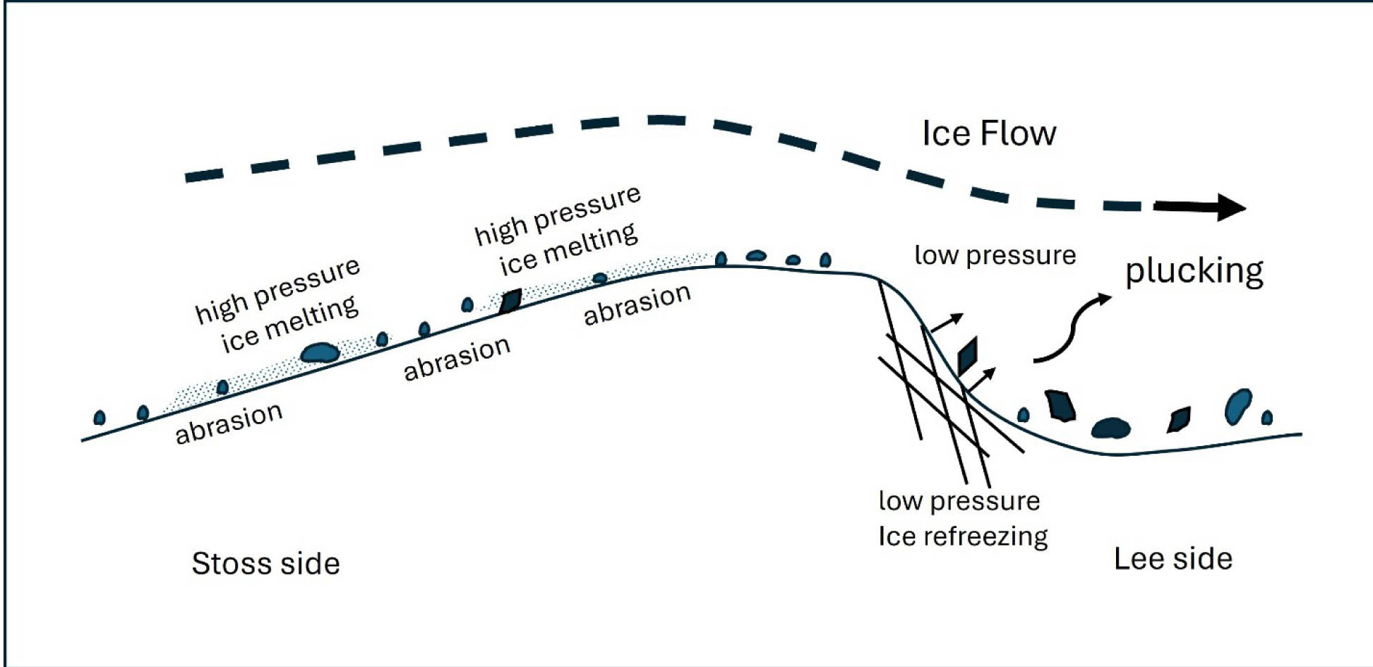
Ice flowing over a whaleback develops a gentle slope by abrasion of entrained rocks against rock up-ice (stoss side) and a more abrupt slope down-ice (lee side) by plucking. Ice melts under pressure, refreezes when pressure decreases. Abrasion leaves striations and plucking develops angular till that is carried down ice (modified from Sugden et al.,1992) and Lamarche et al., 2017).
Where the country rock is homogeneous and relatively soft, like the slates around the Martello Tower in Point Pleasant Park, the scraping by entrained rock blocks and polishing by sand grains creates smooth surfaces with striations that indicate the direction of the last flow of the ice (glacial striations in 2 directions can be observed on the slates by Martello Tower).
Where there are variations in rock types, the hard rocks, igneous rocks like granite, the surface is eroded less than areas with softer rocks like slates and tend to form highlands (in Nova Scotia the South Mountain and the North Mountain are cored by hard igneous rocks), whereas softer (or more fractured) rocks form valleys. For instance, the Backlands are highlands compared to the Northwest Arm which is underlain by slates.
In granite terrains, ice flow typically forms rounded hummocky landforms which from a distance mimic flocks of grazing sheep, appropriately baptized by the French as roches moutonées (sheep-like rocks); elongated ones we call “whalebacks”, like a pod of cetaceans swimming in a particular direction. The elongation of the whalebacks is parallel to the direction of past ice flow; in our case ice flowed predominantly from northwest to southeast.
These whalebacks are smoothed by glacial erosion on tops and sides, and they have a gentler slope on the upstream ice flow side and drop off more abruptly on the downstream side. The whalebacks in the Backlands will have a gentle slope to the northwest, and a more abrupt end to the southeast.
Till
Loose rock entrained by the moving ice is called “till” (Scottish term for coarse, obdurate land, the soil developed on the stony clay that covers much of northern Britain), tends to accumulate at its edge or base, where the ice thaws, in our case probably offshore as far as Sable Island, but because of vagaries of the regime of ice flow, often gets trapped close by, in areas of change of the bedrock. Jumbled, angular blocks accumulate and form fields of difficult access, like the one just north of Frog Pond. Some of the blocks have one flat polished side, which shows they were once at the surface, and abraded and polished by ice-entrained rocks.
Erratics
Some larger entrained blocks are carried long distances by the ice and called “erratic” blocks, and when the ice melted, they were gently posed, some in precarious positions. There are a few erratics on the Backlands, but most notable are the giant “rocking stones”, one perched near the steep slope above Purcell’s Cove and another found in Spryfield’s Kidston Lake Park.
Drumlins
A flowing glacier can shape thick deposits of till into streamlined or fluted landforms, called “drumlins” (from the word Gaelic word druim for a rounded hill. Drumlins are generally oval shaped with the steeper slope facing the direction from which the ice flowed, as opposed to whalebacks, which are steeper in the down-ice direction. They tend to form in places where the underlying rocks are more “sticky”, like soft slates.
A small, poorly formed drumlin with tall trees accumulated uphill of the Royal Yacht Squadron. A prominent drumlin is Citadel Hill, made of gravelly, clayey till and therefore appropriate for easily digging military defenses.
Their makeup of soils with good permeability enhances the growth of tall stable trees which can develop deep roots, in contrast to trees that grow on bedrock.
Drumlins afford great agricultural land like in the area of Lunenburg, and slowly deliver sand for beaches without a river to provide it, such as the sandy beaches by Lawrencetown.
A note about the granite.
The granite exposed in the Backlands is part of the largest intrusive complex (called the South Mountain Batholith) of the Appalachian mountains. It was intruded 380 million years ago a great depth (some 8 km) in a Himalayan-like mountain belt, emplaced into folded marine and metamorphosed rocks of ca. 450 million years (Paleozoic), now exposed as black (carbon-rich) slates in places like Purcell’s Cove and Point Pleasant Park.
The glaciers scraped the surface last time about 11,700 years ago, but the landscape was already exposed 300 million years ago (Carboniferous) and was eroded to near sealevel 100 million years go (Cretaceous). The granite in some parts is homogeneous and relatively devoid of fractures and was deemed excellent for quarrying as building stone since 1790 to 1953 in the historic Purcell’s Cove Quarries.
References
Lamarche et al. (2021) Roche moutonnée – Géologie Québec (gouv.qc.ca).Top of Form
Sugden, D. E., Glasser, N., & Clapperton, C. M. (1992). Evolution of Large Roches Moutonnées. Geografiska Annaler: Series A, Physical Geography, 74(2–3), 253–264. https://doi.org/10.1080/04353676.1992.11880368
More exciting information about the effects of ice on the Maritime Provinces can be found in: Chapter 8: Into the Ice Age, pp167-193, of the book The Last Billion Years, by Robert Fensome and Graham Williams (Eds.) 2022 and the Atlantic Geoscience Society, Nimbus Publishing. ISBN: 9781774710630. Available at local bookstores and Books | Atlantic Geoscience Society
Page posted by David P June 30, 2024