
Our HRM Alliance Hotspots: Williams Lake, Purcell’s Cove and the “Backlands”
Williams Lake, Purcell’s Cove and the “Backlands” together are one of five development HotSpots in HRM which exemplify how their Greenbelting Solution would help preserve natural areas, save the Municipality money and maintain recreational and cultural uses. For an update on the Sewer and Water issue, see City sinks Purcells Cove water plan.
 McIntosh Run Watershed Association
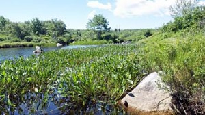
The upper part of the MacIntosh Run begins at the outflow from Long lake and goes through residential neighbourhoods. The lower part goes through the backlands and flows into the sea at Herring Cove. The Association has built an active transportation trail alongside the upper part of the run. They envisage extending the trail the entire length of the run, including a wilderness trail which would be “a rugged trail across the backlands to Herring Cove; the trail will be varied, in some places climbing along bedrock ridges, and in other places hugging the river’s edge.”
Purcell’s Cove Neighbourhood Committee
“The Purcell’s Cove Neighbourhood Committee (PCNC) exists to promote community development in our neighbourhood. This website gives us a way to share information.” Their Submission of July 13, 2013 provides an overview of who they are and why they want to protect the backlands.
Williams Lake Conservation Company (WLCC) 
The primary objective of the WLCC as contained in its Memorandum of Association (1980) is “to preserve, for recreational, aesthetic, health, and other purposes’ Williams Lake.” Towards that end, the WLCC is concerned with the health of the entire watershed including Colpitt Lake. The once proposed development of the McCurdy Estate Lands to the south and east of Williams Lake has been a major concern recently. However Clayton developments and the parent company, the Shaw Group, have now put forward a proposal for partnering with the Nature Conservancy of Canada and HRM to conserve these lands. Currently (early June, 2016) HRM staff are working on a report at the request of Regional Council (see Post of May 3, 2016). If this plan goes ahead, it would protect the largest block (162 ha) of privately owned land in the Backlands and go a long way towards protecting as much of the Backlands as possible.
Purcells Cove Conservation Lands
Page on the Halifax Field Naturalists (HFN) website. The Purcells Cove Conservation Lands, administered by the Nova Scotia Nature Trust, are the only formally protected lands in the Purcell’s Backlands.
Fine Art: Geoffrey Grantham
 Geoffrey lives in the Purcell’s Cove area and has painted many of the landscapes in the backlands. This site includes images of some of his wonderful work.
A trail plan for the Wildlands : an area bounded by Herring Cove Road, Purcells Cove Road, and Williams Lake Road in Halifax, Nova Scotia
Kevin Gerhardt Gray. Thesis/dissertation, Dalhousie University, School of Planning. 2005. 143 pp. Available as electronic resource from Dal Killam Library.
View Map from thesis on Williams lake Conservatopn Company website where it is noted: We thank Kevin Gray, Masters in Urban Planning (2005), for this trail map. Property boundaries for the Clayton Developments and Armco lands have been added. Note: more recent trails are missing from this map.
Thesis Abstract: Trails provide a wealth of benefits to communities. Trails can offer their users alternative routes of transportation, scenic walks, or fresh air. They can be used to link one community to another by paths that have existed for generations. The Wildlands remain one of the few unspoiled areas within minutes of the Halifax downtown core. The Halifax Regional Municipality (HRM) has referred to the area in parkland plans but has not proposed a design. As more and more people become aware of the natural Wildlands, there is an increasing need for a viable trail design. This thesis offers a trail design as a means to advance the Halifax Parkland Strategy. This study was undertaken to create a trail design for the Wildlands of the Halifax Regional Municipality (HRM). The project reviews trails by taking a close look at classification, types, municipal policy, liability and management. In order to present an idea, the trails were mapped using the Global Positioning System (GPS) and mapped using a Geographic Information System (GIS). The subject of trails has emerged in recent years as a topic of importance. Communities are passionate about their natural resources and should be involved in the trail planning process.
 Regeneration of Forest and Barrens after the Spryfield Fire of April 30, 2009
This photo-essay illustrates the regeneration of vegetation over 16 months after an intense fire swept through forest and barrens in the vicinity of Spryfield, Nova Scotia on April 30, 2009. The fire destroyed twelve homes. The photos are from two areas: the Purcell’s Cove Conservation Lands, and on crown land in the vicinity of Lower Mud Pond. This landscape is particularly fire-susceptible and supports a unique plant community adapted to recurrent fires.
Protected Areas & Parks on the Chebucto Peninsula
Map on the WRWEO website shows Protected Areas, Parks, Crown Land (including Crown Land in the Purcell’s Backlands) on The Chebucto Peninsula and potential connectivity between these areas.
Pine Island Ponds Loop canoe trip: the report
A report by Dusan Soudec of Canoe-Kayak Nova Scotia on this canoe route through the lower MacIntosh Run (Aug 14, 2010)
A Tail of Two Trails
Report on two hikes into Purcell’s Cove Backlands (PCCL, Aug. 25 and Williams-Colpitt Lakes, June 1, 2012) for the Halifax Field Naturalist
Land Ownership
Go to www.viewpoint.ca and search for Purcell’s Cove