
Wetlands & Wetland Vegetation in the Backlands.
Base Map from NS Provincial Landscape Viewer.
Click on images for larger versions
Mapped wetlands in the Backlands amount to approx. 6.5% of the total area, similar to the average for NS (6.6% in freshwater wetlands).
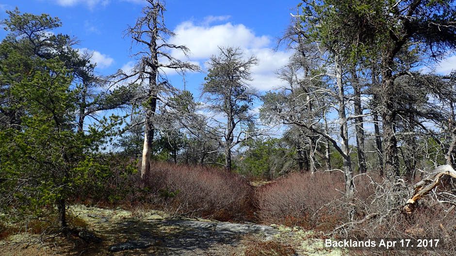
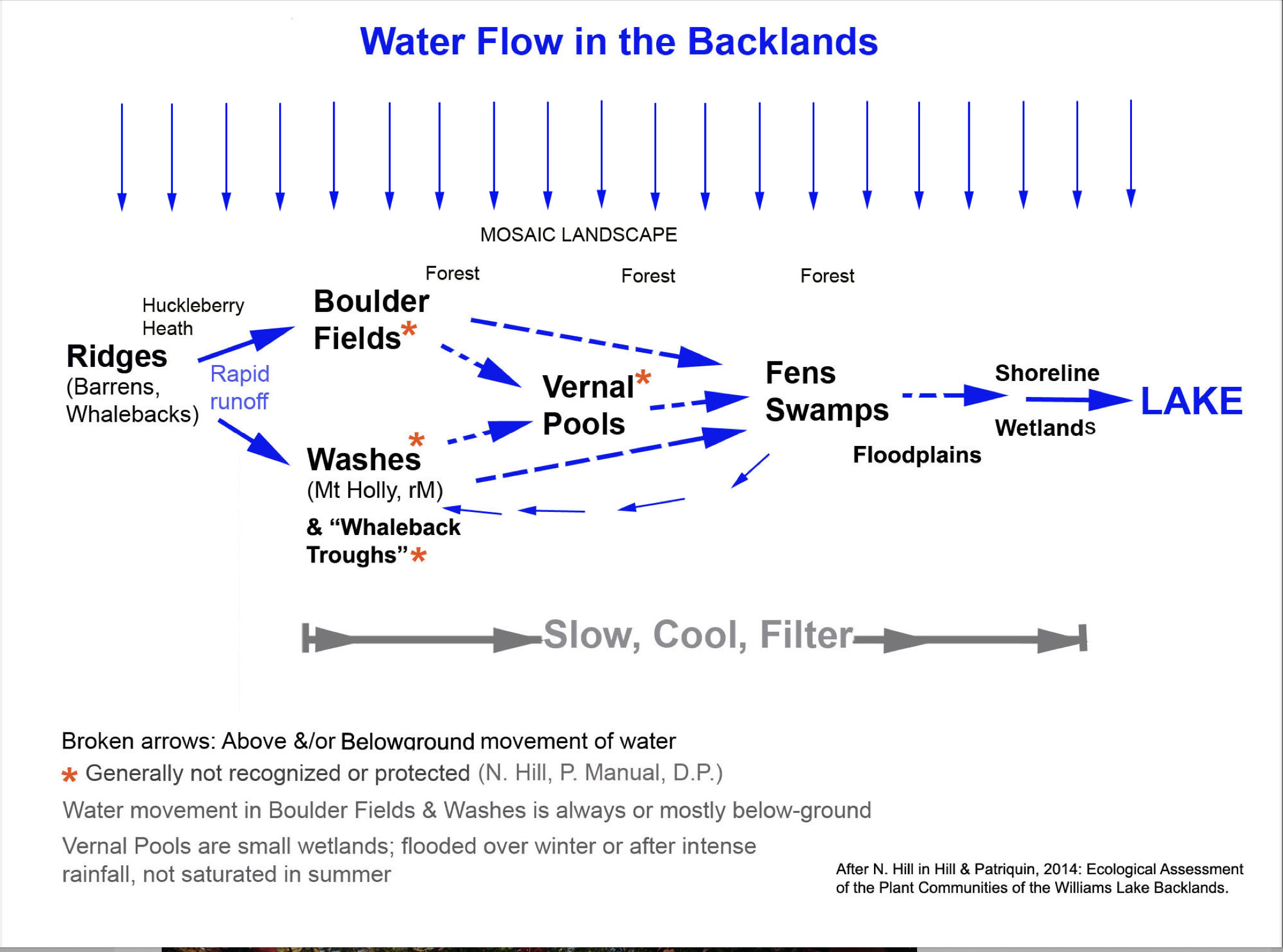
However, smaller wetlands/seasonal watercourses in the form of Boulder Fields, Mt Holly Washes, Vernal Pools and Whaleback Troughs in this landscape would likely more than double that figure. As documented by N. Hill* the water regime in the Halifax Backlands has features of dryland systems, with these intermittent stream courses probably accounting for a majority of the water flow. There are only a few bogs in the Backlands.
*Ecological Assessment of the Plant Communities of the Williams Lake Backlands
N. Hill and D. Patriquin, Report to The Williams Lake Conservation Company (Feb 13, 2014).
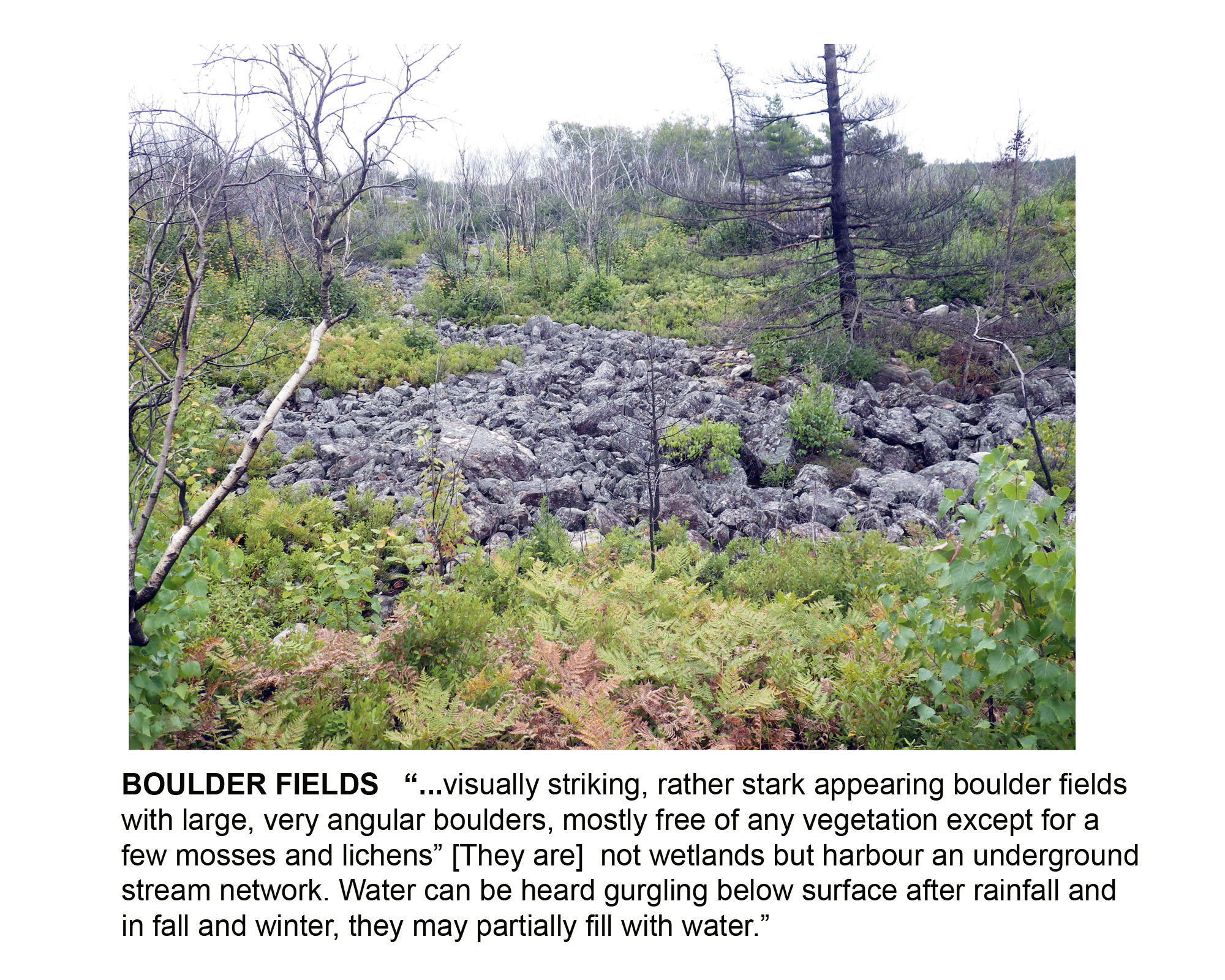 Boulder Fields |
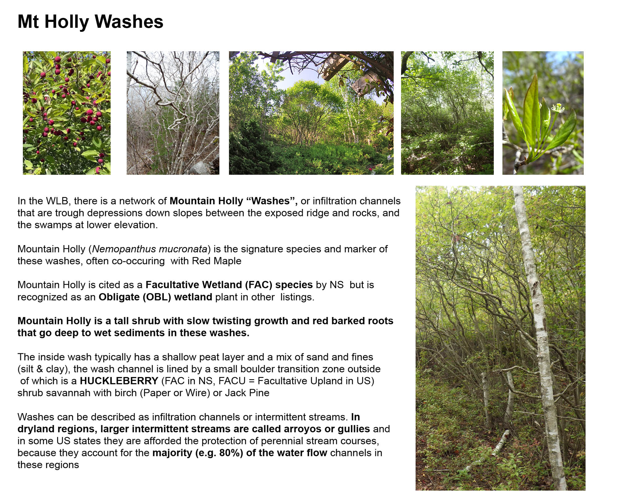 Mt Holly Washes |
 Vernal Pools |
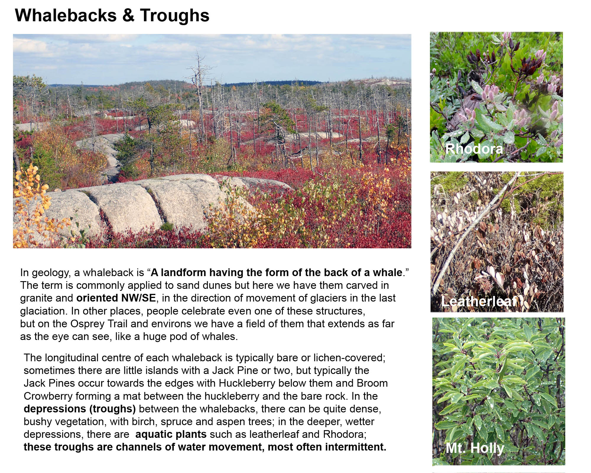 Whalebacks & Troughs |
SOME SOURCES & RESOURCES
Pertaining directly to wetlands and watercourses in the backlands
Wetlands–natural defence against wildfires
Article by Cathy Vaughan in the Chebucto News Vol 25(2) Oct 2023, pp1-2. “Wildfires have slammed our local communities recently and heightened our awareness of the results of human activity on climate change. Besides the practical tasks, such as emergency evacuation preparedness, we are now looking to the science of wetlands as a valuable and available natural defence against wildfires.
WORLD WETLANDS DAY 2023 WORKSHOP IN HALIFAX REGIONAL MUNICIPALITY: What We Heard Report
“This report was written and prepared by Dr. Patricia Manuel, Mimi O’Handley(Ecology Action Centre), Becky Parker(Nature Nova Scotia), and a staff member from Halifax RegionalMunicipality.” Oct 2023, 14 pages. “On February 2, 2023, World Wetlands Day, the Ecology Action Centre, Nature Nova Scotia, and Halifax Regional Municipality (HRM) conducted interactive workshops on the protection and management of wetlands in Nova Scotia. Both workshops took place at the Captain William Spry Community Centre in Spryfield, HRM. The morning workshop, hosted by all three organizations, brought together primarily government and NGO stakeholders with interests in wetlands, natural areas, and watershed protection and management. The second workshop, hosted in the evening by the Ecology Action Centre and Nature Nova Scotia, was geared toward the general public.
Watersheds, Watercourses and Wetlands of the Halifax Backlands
Webinar presentation by David Patriquin on Aug 15, 2023 with Q&As. For Ecology Action Centre and Nature Nova Scotia Lunch & Learn: Wetlands, Adaptations and Extreme Weather Events.
– YouTube Video
– Slides for the presentation (29 slides, 18 MB)
– Summary(Text)
Ecological Assessment of the Plant Communities of the Williams Lake Backlands
N. Hill and D. Patriquin, Report to The Williams Lake Conservation Company (Feb 13, 2014).
Water Channels to Wetlands in the Williams Lake Backlands
by Nick Hill and David Patriquin, 2014. 36 pages, 6 MB file. Pages extracted from Ecological Assessment of the Plant Communities of the Williams Lake Backlands. Includes a key to wetland types, descriptions of water flow, relevance to conservation.
Vernal Pool Mapping in the Williams Lake Watershed, Halifax
Project Report by Huan Liu, Dalhousie School of Planning, 2012. This project tested several remote sensing approaches for documenting vernal pools by employing them individually in mapping potential vernal pools in the undeveloped area of the central Williams Lake Watershed. Field observations examined the accuracy of the predictions and an evaluation of the methods and data that this project used.
Pristine Shoreline of Colpitt Lake (Video)
David P paddles the shoreline on June 20, 2015 and comments on what he sees.
Water quality measurements on Williams Lake and Colpitt Lake (Halifax, N.S.) Dec 7-13, 2015 with reference to possible impacts of road salt
Report to Williams Lake Conservation Company (WLCC) by David Patriquin, Jan 6, 2016. There is evidence for delayed (or possibly absence) of the fall turnover of the water column in Williams lake which may be related to salt induced stratification. Conditions have clearly deteriorated since 1990/1991. Even though three-quarters of the watershed is undeveloped, salt inputs from the other 1/4 are having significant impacts on the health of both Colpitt Lake and Williams Lake.
CB Observations Gov. Bk/Colpitt Lake
Charles Bull has been conducting “Citizen Science” observations on Electrical Conductivity (a measure of salt content) & Temperature of surface waters at 3 locations in the upper Williams Lake Watershed. (Page on this website.)
Osprey Trail: pine barrens & whalebacks
(Page on this website.)
Exotic & Invasive plant species on Lawsons Brook
A mid-summer 2023 Survey (Page on this website.)
Regeneration of Forest and Barrens after the Spryfield Fire of April 30, 2009
Photo-essay by Richard Beazley and David Patriquin. On April 30/May 1, 2009, an intense forest fire “cut a swath though Spryfield, Purcell’s Cove and Ferguson’s Cove.” (Chronicle Herald May 2, 2009). This set of photos illustrates the regeneration of vegetation over the ensuing 16 months.
Some Pertinent Docs & Links (HRM & Provincial)
Mapping wetlands in Nova Scotia with multi-beam radarsat-2 polarimetric sar, optical satellite imagery, and elevation data
Raymond Jahncke, MES Thesis, Dalhousie University, 2016
Nova Scotia Wetland Conservation Policy
Released in 2014, the policy was updated in 2019.
A Citizen’s Guide to Wetland Conservation in the Halifax Regional Municipality
Prepared by East Coast Environmental Law In partnership with the Ecology Action Centre with support from the Sage Environmental Program 20 February 2014
Nova Scotia Wetland Mapping
MTRI YouTube Webinar “Wetlands are incredibly diverse, coming in many different shapes, sizes and types, think of open grass-filled marshes compared to wet forests… On Aug 14, 2023, John Gallop, Wetland and Water Resource Specialist at Nova Scotia Environment and Climate Change discussed his department’s work on a LiDAR-based Wet Area Mapping (WAM) for Nova Scotia and this summer’s fieldwork to verify the maps and improve the model.”
Wetlands: Some Literature and links relevant to wetlands in Nova Scotia
Page on www.versicolor.ca/sandylakebedford/
Surveying vernal pools in Halifax County, Nova Scotia to identify landscape correlates of pool features and pilot a survey methodology
Anna Bishop, ENVS 4902 Environmental Science Undergraduate Honours Thesis (on DalSpace) “…This project has provided baseline data on the characteristics and features of vernal pools in Halifax County, which lays the groundwork for future research in other geographic regions in NS. Ultimately, it provides some first steps towards protecting vernal pool ecosystems from anthropogenic impact within NS.
Forested Wetlands in Nova Scotia. (YouTube)
Rachel Kendall on Nature NS Webinar July 4, 2023.”Rachel is currently working as a Research Associate with NSCC Applied Research. She gained professional recognition with her paper on the role of forested wetlands as carbon sinks in southwest Nova Scotia. This research showed that forested wetlands store more carbon in the soil than adjacent upland forests! This is important information to guide decision-making around wetlands and this was the first carbon budget study of forested wetlands in Nova Scotia. In this talk, Rachel will give a background on wetlands in Nova Scotia, explain how she did this research and the results, and highlight studies conducted by other researchers as part of the large collaborative forested wetlands research in Atlantic Canada.” See also: R. Kendall et al., 2020. The role of temperate treed swamps as a carbon sink in southwest Nova Scotia. November 2020Canadian Journal of Forest Research 51(2)
Vernal Ponds
March 2023 talk by John Brazner to Blomidon Field Naturalists