Hello Neighbours and Friends of the Purcell’s Cove Backlands,
This Thursday our Municipal Council will be considering and voting on two key cases pertaining to the zoning of the Purcell’s Cove Backlands. For those of us who wish to conserve the Backlands, save them from higher density development and prevent loss of life and property from building in this known wildfire-prone area, it is critically important that we provide our feedback to Council in advance of this meeting and/or register with the City Clerk to do a presentation to Council.
REQUESTED ACTIONS:
- Please attend the Public Hearing at 1 pm, Thursday, June 19 at City Hall
- Register now to speak for up to 5 minutes at the meeting by emailing clerks@halifax.ca (you may bring to the meeting two “slides” of your choosing printed on 8 1/2″ x 11″ paper, which can be projected during your presentation)
- Send an early written submission in advance of the meeting from you, your organization and/or encourage your members to do so as well.
At this Public Hearing, Council will be considering and voting on the following two Backlands cases as a part of the Phase 4 HRM Regional Plan Review Process:
1. Purcell’s Cove Backlands, Purcell’s Cove | Case 22257HRM initiated a request to review all lands in the Urban Reserve Designation in the Purcell’s Cove area, as a result of HRM’s acquisition of Shaw Wilderness Park in 2018.
For many years, the Backlands Coalition, property owners and the broader public have been in discussion with HRM Planners about future zoning changes affecting privately owned lots in the Purcell’s Cove Backlands. Since December of 2023, HRM has been proposing the following Phase 4 amendment, as it would minimize development in the most fire-prone areas of the Backlands, where housing cannot be safely built. The proposed amendment (which was made available for all to see on the HRM website) was the following:
- Acknowledge that an urban form of serviced development is no longer envisioned in this location;
- Re-designate and rezone the Shaw Wilderness Park lands to Open Space and Natural Resources Designation and the Regional Park Zone to reflect its current use;
- Re-designate and rezone other publicly owned lands and private conservation lands to the Open Space and Natural Resource Designation and the Protected Area Zone;
- Re-designate privately owned Urban Reserve lands to Rural Commuter within a specified and limited distance of Purcell’s Cove Road, apply the Open Space and Natural Resource Designation to the remainder of the properties, and apply a new Purcell’s Cove Backlands Designation and Zone within the Halifax Mainland Secondary Municipal Planning Strategy and Land Use By-law to the lands.
Our recommendations for your Submissions to Council
- We recommend that Council pass the above carefully considered amendment in Phase 4 of the Regional Plan Review. (We do not think this decision should be postponed until Phase 5, as an approximately 2,000-page very recently published HRM Planning document has recommended.)
- It is critically important that Council strictly define how far back from Purcell’s Cove Road lot owners will be permitted to develop their lots and build houses. We must be unified in advocating for development of lots no farther back than 100 metres from Purcell’s Cove Road, as we had previously discussed with HRM Planners. (This will greatly minimize the number of houses property owners will be allowed to build in the future and prevent houses from being built in a known Wildfire Zone.)
- We should request that Council establish an incentive program for property owners along the Purcell’s Cove Road who own long, narrow lots fronting on the Purcell’s Cove Road. These lot owners should be allowed to subdivide ONLY for the purpose of donating the back part of their lots to the Nature Conservancy and/or Nova Scotia Nature Trust for conservation. For this they should receive the largest tax deduction possible.
- The fire hazard of developing lots farther back than 100 metres from the Purcell’s Cove Road is REAL and only increasing. The Purcell’s Cove Backlands must be considered a “no-go zone” for building. There is plenty of evidence to justify this stance: there was the massive wildfire of 2009 when many houses (particularly on Aaron’s Way) were burnt to the ground. Thousands of people had to be evacuated from the area. During this same fire, several houses on Fortress Drive were damaged — the wildfire jumped across the Purcell’s Cove road, leaving residents to flee for their lives, with only minutes of notice.
- There was a subsequent wildfire on the Bess/Shaw Land in 2012, which burned very close to Oceanview Drive. Additionally, there was the harrowing fire in Hammonds Plains/Upper Tantallon only 2 years ago that is worth referencing — a truly catastrophic fire and a cautionary tale for us all: 151 homes burned to the ground and 969 hectares of land burned in these HRM subdivisions. It is a miracle that no human lives were lost during this incredibly intense, rapid-moving wildfire.
- If people are permitted to build upon this known Wildfire Zone in the Purcell’s Cove Backlands, one can foresee future lawsuits after lives are lost, people are injured and houses/properties are burnt to the ground. Statistics show that these wildfires are only becoming more and more frequent, ferocious and destructive. In the aftermath of the 2009 Purcell’s Cove Backlands wildfire, 18 separate lawsuits seeking a total of $10 million in damages were filed against HRM and Halifax Regional Fire & Emergency Service. HRM had to settle and pay out an undisclosed amount to the insurance companies that filed the lawsuits. Halifax Fire Facing 18 Suits & $10 Million in Claims for 2009 Wildland Fire – Fire Law Blog; HRM, fire department sued for wildfire | CBC News
- Advancing the wildland-urban-interface in a wildfire prone landscape is definitely a poor strategy for development, especially into a known fire landscape.
- It is critical that Councillors reflect on how climate change is pushing fire-favourable conditions in Nova Scotia. We have hotter, drier summers (lower precipitation and loss of snow cover in winter, as well, also means a lower water table). The new climate is ratcheting up the fire conditions in already fire-prone landscapes. Natural Resources Canada has forecasted a higher than average fire severity risk for June and August for parts of mainland NS: Canadian Wildland Fire Information System | Monthly and Seasonal Forecasts; Seasonal forecasts for Canada
- These private Urban Reserve lands under discussion in the Backlands are no longer being considered for serviced development; they cannot contribute to easing the housing shortage in any real way, and certainly not affordable housing. Therefore, any further development of these lands serves no useful purpose, while preserving the natural attributes of the Backlands does in so many ways.
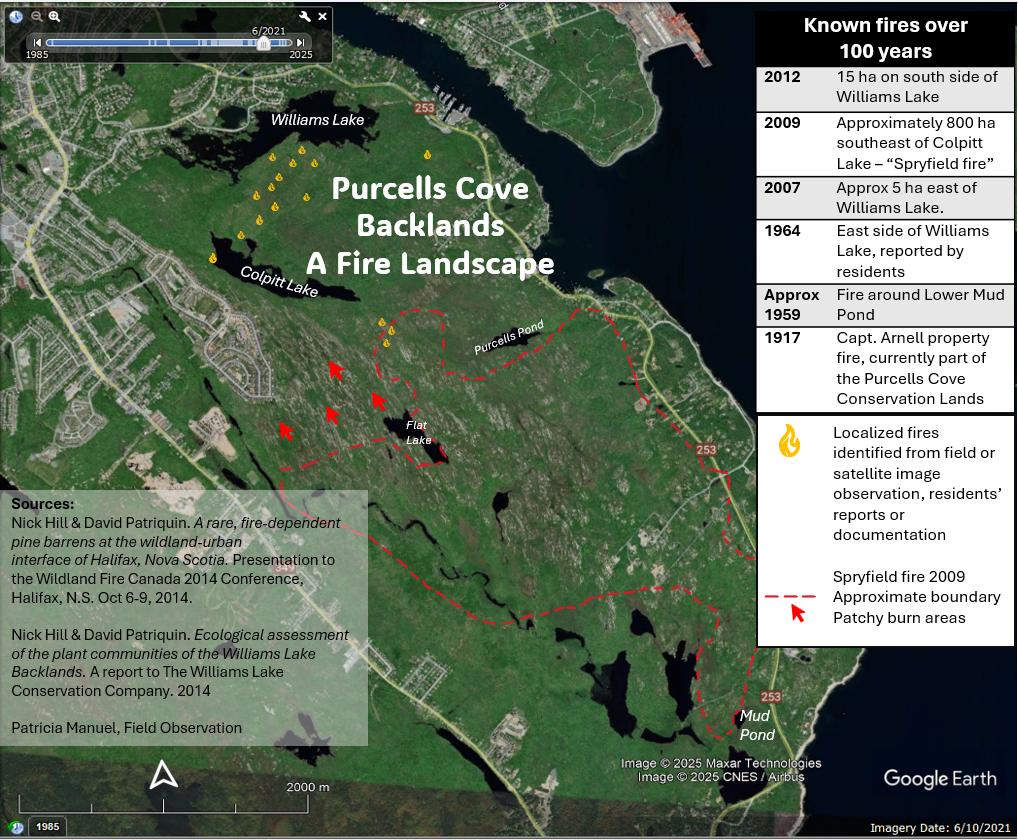
Please feel free to draw, copy and paste from the points listed above for your submissions and/or presentations to Council at this critical juncture for the fate of the Purcell’s Cove Backlands. (Also see attached map of the Purcell’s Cove Backlands, which we encourage you to add to your submissions.)
2. Lands on Purcell’s Cove Road | Case 025
Please help convince HRM Council that the centuries-old path and key access point to Williams Lake remains available to the HRM community! If we don’t act now, the public may lose access to this treasured, historic swimming lake.
This case pertains to the private 9.4 acre lot on Purcell’s Cove Road (between Shaw Wilderness Park and Halls Road), which thousands of residents from across HRM use to access Williams Lake annually over a long-established footpath to this popular swimming lake.
There has been a request from ZZap Consulting Inc., on behalf of the property owner Tony Maskine, to redesignate the property to permit an unserviced subdivision. HRM has proposed an amendment to:
- Redesignate the lands to Rural Commuter and apply zoning that will permit large lot subdivision.
- Under the Regional Subdivision Bylaw, Purcell’s Cove Road (Route 253) is a “Schedule K” road; lots in the Rural Commuter designation on Schedule K roads must have a minimum of 61 metres of public road frontage.
- The existing lot has approximately 355 metres of frontage; therefore, it is anticipated that the proposed amendments will permit subdivision for a maximum of 5 lots.
- A watercourse buffer (30 metres under the proposed Regional Plan), will apply from Williams Lake (with the potential for relaxations).
Why is this land special?
- The path from the Purcell’s Cove Road to Williams Lake has been used by the public (including Joseph Howe) for centuries for lake access via a sheltered bay and adjacent promontory for swimming, boating, fishing and skating.
- There is a rare and healthy old growth grove of hemlock and white pine, which should be preserved.
- There is extensive wildlife thriving on this land, including Barred Owls.
- The land is adjacent to Shaw Wilderness Park and is a wildlife corridor.
- The land is dotted with large wet areas, vernal ponds and streams — critical wetlands.
- The land is situated on Williams Lake so there is concern about possible degradation of water quality if careful consideration is not taken in its stewardship; Williams Lake is already stressed from surrounding residential development.
In your submissions and/or presentations to Council, please ask for the following approach to be adopted:
- Subdivide this land into no more than 5 lots on the southeast side away from the existing historic footpath, watercourse buffer and significant slope.
- Use Section 83 of the HRM subdivision regulations for a parkland allocation of the land to preserve the public path on the west side extending from the Purcell’s Cove Road to, and including the cove and peninsula. This would allow for access to the lake for the public. (Section 83 states: ‘where the land being subdivided abutts a natural watercourse, a portion of the lands to be dedicated to the municipality shall provide at least one point of access to the shoreline which is usable for water-based recreational activities’.)
- Given the significance of the lakeshore to the Halifax Public and the long history of the path, as well as the hemlock and white pine groves that would be protected with this dedication, the developer should not be allowed to provide ‘cash-in-lieu’ instead of a parkland dedication.
- The parkland dedication should include footpaths, trails, watercourses and the riparian buffer.
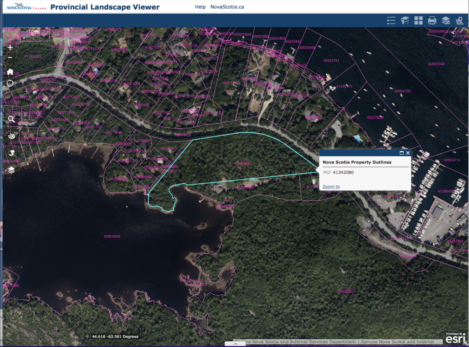
Please use the above bullet-points to write a letter to the Mayor and Councillors so that we can save this special place and the path to Williams Lake! (Also see attached map of this 9.4 acre lot where “Lovers Lane”, the footpath to Williams Lake, is located.)
Come to the Public Hearing so that your voice can be heard! And many thanks in advance for your submissions. Recent history has shown that if we engage and stand up for the preservation of the Purcell’s Cove Backlands, we truly can make a difference.
Best regards,
The Backlands Coalition